Author Topic: Hurricane Ian Thread  (Read 38388 times)

0 Members and 2 Guests are viewing this topic.

Offline libertybele

  • Cat Mod
  • *****
  • Posts: 65,235
  • Gender: Female
Hurricane Ian Thread
« on: September 21, 2022, 03:57:22 pm »
It's out a ways, but by the looks of the project track on the map, hurricane coming up that side of the Gulf are never a good sign for around me. 


A hurricane in the Gulf of Mexico next week? Forecasters warn of 'significant threat' to US.

A developing tropical system could spin up into a hurricane in the Gulf of Mexico by the middle of next week, forecasters warned Wednesday.

"This is the most significant threat for the U.S. mainland we've had this hurricane season," AccuWeather chief meteorologist Jonathan Porter said.

The system, known now as Invest 98L, was located near the northeastern coast of South America on Wednesday.

An "Invest" is an area that the National Hurricane Center is watching closely with advanced computer models and other resources, including the Hurricane Hunters, for possible development, according to Weather.com.


https://www.yahoo.com/news/hurricane-gulf-mexico-next-week-173738962.html

« Last Edit: September 26, 2022, 11:21:58 am by jmyrlefuller »

Online Bigun

  • Hero Member
  • *****
  • Posts: 34,761
  • Gender: Male
  • Resistance to Tyrants is Obedience to God
    • The FairTax Plan
If you live anywhere near the Florida panhandle the time to start making preparations is now.
"I wish it need not have happened in my time," said Frodo.

"So do I," said Gandalf, "and so do all who live to see such times. But that is not for them to decide. All we have to decide is what to do with the time that is given us."
- J. R. R. Tolkien

Online catfish1957

  • The Conservative Carp Rapscallion of Brieferville
  • Political Researcher
  • *****
  • Posts: 25,404
  • Gender: Male
My take on 98L at this point.

GOM's basically been untapped as a heat sink for the entire summer.  This might get ugly.

Over half the Models have this as a Cat 3 or Cat 4, and this is just at the 168 hr, point. 

As expected @168 hr.  early models have a pretty wide spread from mid Yucatan to about 75 west of Tampa. Except for the 2 models heading toward Yucatan, and 2 through western Cuba  the other 11 or so thread the channel between Yucatan and the Keys.

Being late September, and now seeing some fronts and troughing from the north CONUS, I am leaning toward this being more of an eastern GOM threat.  OTOH, if this follows the more western track, I think almost the entire GOM is into play.

But, as I like to remind my fellow Texans,.....  There has never been a Major hurricane strike to Texas after October 1.  Just a meterorlogical fact that takes in account the troughs and fronts I mentioned earlier.
« Last Edit: September 21, 2022, 04:32:23 pm by catfish1957 »
I display the Confederate Battle Flag in honor of my great great great grandfathers who spilled blood at Wilson's Creek and Shiloh.  5 others served in the WBTS with honor too.

Offline DefiantMassRINO

  • Hero Member
  • *****
  • Posts: 11,959
  • Gender: Male
Holy crap!  That storm will bomb out (bombogenesis) over the Gulf of Mexico.  The only thing that could prevent that is wind shear in upper levels of the atmosphere.

Water Temperature Table of the Eastern Gulf of Mexico
https://www.ncei.noaa.gov/access/coastal-water-temperature-guide/egof.html

Water Temperature Table of the Western Gulf of Mexico
https://www.ncei.noaa.gov/access/coastal-water-temperature-guide/wgof.html
"Political correctness is a doctrine fostered by a delusional, illogical minority, and rabidly promoted by an unscrupulous mainstream media, which holds forth the proposition that it’s entirely possible to pick up a turd by the clean end." - Alan Simpson, Frontline Video Interview

Offline libertybele

  • Cat Mod
  • *****
  • Posts: 65,235
  • Gender: Female
If you live anywhere near the Florida panhandle the time to start making preparations is now.

....hmmm as of right now where they show this hurricane heading is towards the southern portion of FL. It looks like it's going to come up somewhere on the western side of the Gulf (not good for our area).  This is the same path that Charley took and was a Cat 4 (which we stayed through)......

I don't see it hitting the panhandle at all.  Just my opinion.

I'm hoping at this point that it fizzles out and is a tropical storm.

Hurricane Donna back in the '60's took a similar path and she came up the coast and then turned back and pummled areas of southern FL.

P.S. Either way, I'm not dodging this one. I have too many health issues to be riding in a car trying to escape.
« Last Edit: September 21, 2022, 04:56:37 pm by libertybele »

Offline libertybele

  • Cat Mod
  • *****
  • Posts: 65,235
  • Gender: Female
ORLANDO, Fla. – Ten days after the peak of hurricane season, the tropics are very active, with Hurricane Fiona expected to reach Category 4 status on its approach toward Bermuda, a new tropical storm and a tropical wave, now known as Invest 98L, that many models show potentially moving into the Gulf of Mexico.

Fiona dumped copious amounts of rain over the Dominican Republic and Puerto Rico, where a 58-year-old man died after police said he was swept away by a river in the central mountain town of Comerio. Another death was linked to the blackout — a 70-year-old man who was burned to death after he tried to fill his generator with gasoline while it was running, officials said.

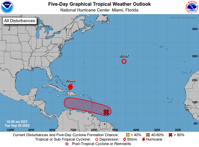
Meanwhile, Invest 98L, several hundred miles east of the Windward Islands, has become better organized. Additional development is expected, with a tropical depression likely to form within the next few days as the system moves west to west-northwest at 15 to 20 mph across the eastern and central Caribbean Sea.

The NHC said Invest 98L has a 70% chance of development over the next two days and a 90% chance over the next five days.

Many long-range computer models show the system heading into the Gulf of Mexico, but its projected path and strength are uncertain.


Offline libertybele

  • Cat Mod
  • *****
  • Posts: 65,235
  • Gender: Female
The projected path from the NHC in Miami and the one from AccuWeather are definitely not anywhere close in agreement.

Per the NHC they are supposed to be sending in a reconnaissance aircraft into the system this evening.

https://www.nhc.noaa.gov/

Offline DefiantMassRINO

  • Hero Member
  • *****
  • Posts: 11,959
  • Gender: Male
"spaghetti charts" and "the cone of uncertainty" to follow

... some days I feel like I'm living in a "cone of uncertainty"
"Political correctness is a doctrine fostered by a delusional, illogical minority, and rabidly promoted by an unscrupulous mainstream media, which holds forth the proposition that it’s entirely possible to pick up a turd by the clean end." - Alan Simpson, Frontline Video Interview

Offline libertybele

  • Cat Mod
  • *****
  • Posts: 65,235
  • Gender: Female
"spaghetti charts" and "the cone of uncertainty" to follow

... some days I feel like I'm living in a "cone of uncertainty"

I hear you. With Joe as president I'm definitely living in a cone of uncertainty.

Interesting that they are sending in aircraft this far ahead of time --- perhaps not a good sign. Tomorrow we'll definitely have a better idea.

Yes, the spaghetti models will be flowing freely soon.
« Last Edit: September 21, 2022, 05:42:07 pm by libertybele »

Online catfish1957

  • The Conservative Carp Rapscallion of Brieferville
  • Political Researcher
  • *****
  • Posts: 25,404
  • Gender: Male
The projected path from the NHC in Miami and the one from AccuWeather are definitely not anywhere close in agreement.

Per the NHC they are supposed to be sending in a reconnaissance aircraft into the system this evening.

https://www.nhc.noaa.gov/

Initialization of where the COC (center of circulation) forms is first of utmost criticality.  Right now half of the covection of the wave is over land in South America stretching out maybe 400 miles to the ENE.  That is one of the reasons why there is such a disparity and if wide range in early model runs. Looking at the radar loops it looks like at least right now the center is right at the coast.  The chance of that changing and morphing early on is near 100%.


I display the Confederate Battle Flag in honor of my great great great grandfathers who spilled blood at Wilson's Creek and Shiloh.  5 others served in the WBTS with honor too.

Online catfish1957

  • The Conservative Carp Rapscallion of Brieferville
  • Political Researcher
  • *****
  • Posts: 25,404
  • Gender: Male
Here are some early model runs.  Please realize that this still noes not include the initializtion of a solid COC (storm location).

Of those listed, I have found that the HWFI seems to do the best job taking a good consensus estimate of the potential storm.  Again, this is really early on, so, so much could change as the storm progresses. 

Looking at the 24-168 hr. CONUS model runs seems to show troughing and lack of building Highs during the storm run.  That shows me that this again should indicate a more northern run as the storm gains latitude.  That would favor a <90 degree longitude northward turn.  (Eastern GOM)

General consensus also has the storm a little less robust on wind sppeds (good news), with the line share of models running this as a Cat 1.

I display the Confederate Battle Flag in honor of my great great great grandfathers who spilled blood at Wilson's Creek and Shiloh.  5 others served in the WBTS with honor too.

Online catfish1957

  • The Conservative Carp Rapscallion of Brieferville
  • Political Researcher
  • *****
  • Posts: 25,404
  • Gender: Male
Interesting, the more normal reliable HWFI has become the outlier.  Kind of usual to see this level of consistency in the models this early on.    Overall (again 212-236 hours out) shows a FL strike.  Models are showing a wide range of intensity, from anywhere from a strong tropical storm to a Cat 4 storm.


I display the Confederate Battle Flag in honor of my great great great grandfathers who spilled blood at Wilson's Creek and Shiloh.  5 others served in the WBTS with honor too.

Offline Wingnut

  • The problem with everything is they try and make it better without realizing the old way is fine.
  • Hero Member
  • *****
  • Posts: 22,122
  • Gender: Male
If it does come up the gulf I see westerly winds pushing it inland to central FL.  But that is just my opinion based on past experience with Sept Canes.
You don’t become cooler with age but you do care progressively less about being cool, which is the only true way to actually be cool.

Offline libertybele

  • Cat Mod
  • *****
  • Posts: 65,235
  • Gender: Female
If it does come up the gulf I see westerly winds pushing it inland to central FL.  But that is just my opinion based on past experience with Sept Canes.

I agree with you.  This looks like the same path Charley took in '04.  The forecasters at the time predicted it striking the Tampa area, it took a turn at the last minute and hit south of Tampa striking as a Cat 4 and then went up into the Punta Gorda and Port Charlotte area.

We saw 3 additional hurricanes after that.  Right now there are a couple of others lined up further out with one having a 60% chance formation.

It looks like FL is going to see some action within this week and the following week.  (sigh)
 
« Last Edit: September 22, 2022, 09:11:25 am by libertybele »

Offline libertybele

  • Cat Mod
  • *****
  • Posts: 65,235
  • Gender: Female
Neither the National Hurricane Center or local weather stations are giving any definitive information.  They are all saying it's too early to tell.  We in this area have a new doplar 3X that's supposed to be very accurate -- all they are saying again is it's too early to say anything.

Latest spaghetti models.


Online jmyrlefuller

  • J. Myrle Fuller
  • Moderator
  • *****
  • Posts: 14,694
  • Gender: Male
  • Nonpartisan hack
    • Fullervision
We in this area have a new doplar 3X that's supposed to be very accurate -- all they are saying again is it's too early to say anything.
That I'm assuming is a radar device. Radar is strictly an observation system; it has no predictive power.

Forecast models (i.e., computers) are what do the prediction. Radar can provide a lot of valuable input to models, but they're limited to line of sight, meaning once you get past about 150 miles into the Gulf of Mexico, they're not going to provide anything meaningful. Same goes for surface observations: there are a few buoys out there, but much more sparse than over land.

The vast majority of observation data that goes into these models comes from satellite observations. It's quite remarkable what they can wring out of a camera image—while our eyes only see three primary colors, the current observation systems can see fifteen, spanning from deep into thermal infrared up to ultraviolet, and there are a lot of things that can be deduced by looking at each wavelength.

But still, most of it is inference, and that means guesswork. It's a lot better than it used to be, that's for sure, but I doubt that it will ever be anything near perfect.
New profile picture in honor of Public Domain Day 2025

Offline libertybele

  • Cat Mod
  • *****
  • Posts: 65,235
  • Gender: Female
That I'm assuming is a radar device. Radar is strictly an observation system; it has no predictive power.

Forecast models (i.e., computers) are what do the prediction. Radar can provide a lot of valuable input to models, but they're limited to line of sight, meaning once you get past about 150 miles into the Gulf of Mexico, they're not going to provide anything meaningful. Same goes for surface observations: there are a few buoys out there, but much more sparse than over land.

The vast majority of observation data that goes into these models comes from satellite observations. It's quite remarkable what they can wring out of a camera image—while our eyes only see three primary colors, the current observation systems can see fifteen, spanning from deep into thermal infrared up to ultraviolet, and there are a lot of things that can be deduced by looking at each wavelength.

But still, most of it is inference, and that means guesswork. It's a lot better than it used to be, that's for sure, but I doubt that it will ever be anything near perfect.

Yes it is a radar device and I also spelled doppler incorrectly.  Thanks for the info @jmyrlefuller

Online catfish1957

  • The Conservative Carp Rapscallion of Brieferville
  • Political Researcher
  • *****
  • Posts: 25,404
  • Gender: Male
Yes it is a radar device and I also spelled doppler incorrectly.  Thanks for the info @jmyrlefuller

Haven't pulled up the latest model runs, but that system better move a little further north if it wants to develop. Half of its convection is still residing inland on Venezuelan  coastal land.
« Last Edit: September 22, 2022, 06:28:25 pm by catfish1957 »
I display the Confederate Battle Flag in honor of my great great great grandfathers who spilled blood at Wilson's Creek and Shiloh.  5 others served in the WBTS with honor too.

Offline libertybele

  • Cat Mod
  • *****
  • Posts: 65,235
  • Gender: Female
Haven't pulled up the latest model runs, but that system better move a little further north if it wants to develop. Half of its convection is still residing inland on Venezuelan  coastal land.

I would be just fine if the system doesn't develop.  I definitely don't want to dodge a hurricane right now and some of the spaghetti models have it heading our way and some of the forecasters are predicting a Cat 4.

Local weather is saying once it moves past Jamaica they will be able to forecast a cone and we will know by Saturday with good certainty if it's headed our way.
« Last Edit: September 22, 2022, 08:20:10 pm by libertybele »

Offline libertybele

  • Cat Mod
  • *****
  • Posts: 65,235
  • Gender: Female
It's wobbled a little bit to the north.

Showers and thunderstorms remain disorganized in association with a
low pressure system located over the southeastern Caribbean Sea
about 150 miles east-northeast of Curacao.  The upper-level wind
environment over the low is expected to become more conducive for
development, and a tropical depression is expected to form during
the next day or two while moving west-northwestward at 10 to 15 mph
across the central Caribbean Sea.  Locally heavy rainfall and gusty
winds are likely to affect northwestern Venezuela, the ABC island
chain, and northeastern Colombia through Friday.  Interests in
Jamaica and the Cayman Islands should closely monitor the progress
of this system.


« Last Edit: September 22, 2022, 08:07:16 pm by libertybele »

Offline Wingnut

  • The problem with everything is they try and make it better without realizing the old way is fine.
  • Hero Member
  • *****
  • Posts: 22,122
  • Gender: Male
Yawn.   Too early to GAF. 
You don’t become cooler with age but you do care progressively less about being cool, which is the only true way to actually be cool.

Offline Idiot

  • Hero Member
  • *****
  • Posts: 4,023
It's out a ways, but by the looks of the project track on the map, hurricane coming up that side of the Gulf are never a good sign for around me. 


A hurricane in the Gulf of Mexico next week? Forecasters warn of 'significant threat' to US.

A developing tropical system could spin up into a hurricane in the Gulf of Mexico by the middle of next week, forecasters warned Wednesday.

"This is the most significant threat for the U.S. mainland we've had this hurricane season," AccuWeather chief meteorologist Jonathan Porter said.

The system, known now as Invest 98L, was located near the northeastern coast of South America on Wednesday.

An "Invest" is an area that the National Hurricane Center is watching closely with advanced computer models and other resources, including the Hurricane Hunters, for possible development, according to Weather.com.


https://www.yahoo.com/news/hurricane-gulf-mexico-next-week-173738962.html
Come on baby...right towards West Texas and plan on staying a while.

Offline libertybele

  • Cat Mod
  • *****
  • Posts: 65,235
  • Gender: Female
Come on baby...right towards West Texas and plan on staying a while.

I haven't heard any of the forecasters saying that it could hit TX.  More likely FL they just don't know where on the FL Gulfcoast it will make landfall.

Offline libertybele

  • Cat Mod
  • *****
  • Posts: 65,235
  • Gender: Female
Yawn.   Too early to GAF.

We only have one way north out of here, so if it is headed our way, we will have to evacuate early, especially with all the people that are in the area now. 

I don't think the panhandle has to worry at all.

Yes.  This one has me worried -- hurricane Charley all over again.
« Last Edit: September 22, 2022, 08:25:28 pm by libertybele »

Online catfish1957

  • The Conservative Carp Rapscallion of Brieferville
  • Political Researcher
  • *****
  • Posts: 25,404
  • Gender: Male
Seeing some pretty decent tightening of model data for this early.  Good clustering around western Cuban, and then a NNW/N toward the wester FL Coast or Eastern FL panhandle.

Models also have to some certain clustering agreement of Cat 3 strength at the 96-120 hour point from now.

In just the last few hours there has a big flare up precipitation with a definite spin.  I am guessing this thing is about to get its act together.  If this trend continues, I expct a depression to form tomorrow.


I display the Confederate Battle Flag in honor of my great great great grandfathers who spilled blood at Wilson's Creek and Shiloh.  5 others served in the WBTS with honor too.

Online catfish1957

  • The Conservative Carp Rapscallion of Brieferville
  • Political Researcher
  • *****
  • Posts: 25,404
  • Gender: Male
As I expected our Invest is now T.D.9, and is expected to intensify pretty quickly.  Models are very clustered this early, and the NHC at least at this point has the cone pretty narrow.  NHC graphic of the storm below.  Actual track has strom hitting western Cuba Monday evening as a Cat 2.  U.S. landfall is obviously contingent on how far north the storm hits as a minimum Cat 3.. If it hits in the neighborhood of Tampa or Miami, present estimates are Wednesday, if the storm more veer westward towards the panhandle, I'd guess Thursday.  NHC right now is showing a south of Tampa landfall, but, EVERYONE from the Florida panhandle to eastern FL should prepare.

In fact, all those  east of the Mississippi river to FLshould keep an eye on it too.

I display the Confederate Battle Flag in honor of my great great great grandfathers who spilled blood at Wilson's Creek and Shiloh.  5 others served in the WBTS with honor too.

Online cato potatoe

  • Hero Member
  • *****
  • Posts: 3,723
  • Gender: Male
The path over central Cuba and into the far northwestern Bahamas is still on the table, and definitely a best case scenario.  Second best is the western tip of Cuba followed by landfall in the sparsely populated Big Bend, after ingesting a bunch of dry air.

Offline libertybele

  • Cat Mod
  • *****
  • Posts: 65,235
  • Gender: Female
Well it's coming right at us.  I guess we're riding it out.


Offline DefiantMassRINO

  • Hero Member
  • *****
  • Posts: 11,959
  • Gender: Male
 twilight zonexxxx

What would happen if a nuke was dropped in to the eye of a hurricane and detonated?  Would it weaken the cyclonic forces at the center of the hurricane?
"Political correctness is a doctrine fostered by a delusional, illogical minority, and rabidly promoted by an unscrupulous mainstream media, which holds forth the proposition that it’s entirely possible to pick up a turd by the clean end." - Alan Simpson, Frontline Video Interview

Online catfish1957

  • The Conservative Carp Rapscallion of Brieferville
  • Political Researcher
  • *****
  • Posts: 25,404
  • Gender: Male
The path over central Cuba and into the far northwestern Bahamas is still on the table, and definitely a best case scenario.  Second best is the western tip of Cuba followed by landfall in the sparsely populated Big Bend, after ingesting a bunch of dry air.

There is a sect of dry air moving into the eastern GOM via trough,but I wouldn't count on it in a week.  Plus surface water temperatures in that area are in the upper 80's.

I display the Confederate Battle Flag in honor of my great great great grandfathers who spilled blood at Wilson's Creek and Shiloh.  5 others served in the WBTS with honor too.

Online Bigun

  • Hero Member
  • *****
  • Posts: 34,761
  • Gender: Male
  • Resistance to Tyrants is Obedience to God
    • The FairTax Plan
Well it's coming right at us.  I guess we're riding it out.

Don't mess with this one @libertybele If you can get out do it!
"I wish it need not have happened in my time," said Frodo.

"So do I," said Gandalf, "and so do all who live to see such times. But that is not for them to decide. All we have to decide is what to do with the time that is given us."
- J. R. R. Tolkien

Online cato potatoe

  • Hero Member
  • *****
  • Posts: 3,723
  • Gender: Male
What would happen if a nuke was dropped in to the eye of a hurricane and detonated?  Would it weaken the cyclonic forces at the center of the hurricane?

If the storm is near shore, it may disperse fallout over a wide swath of land.  The circulation would not be disrupted appreciably.

Online cato potatoe

  • Hero Member
  • *****
  • Posts: 3,723
  • Gender: Male
There is a sect of dry air moving into the eastern GOM via trough,but I wouldn't count on it in a week.  Plus surface water temperatures in that area are in the upper 80's.

I'm living about half a mile from Tampa Bay.  This week should be entertaining.

Offline Gefn

  • "And though she be but little she is fierce"-Shakespeare
  • Cat Mod
  • *****
  • Posts: 15,963
  • Gender: Female
  • Quos Deus Vult Perdere Prius Dementat
Is there any word if it might go up the coast as well?
G-d bless America. G-d bless us all                                 

Adopt a puppy or kitty from your local shelter
Or an older dog or cat. They're true love❤️

Online cato potatoe

  • Hero Member
  • *****
  • Posts: 3,723
  • Gender: Male
Is there any word if it might go up the coast as well?

I think most of the US track depends upon how far west it gets this weekend.  The system is so heavily "tilted" northeast to southwest, it is hard to know where things will come together once the shear dies off.  And, a weaker storm this weekend would allow it to drift farther towards mexico before being picked up by the trough.

Online catfish1957

  • The Conservative Carp Rapscallion of Brieferville
  • Political Researcher
  • *****
  • Posts: 25,404
  • Gender: Male
Re: Tropical Depression 9 (September 2022) Thread
« Reply #35 on: September 23, 2022, 11:38:21 pm »
System is now named, Ian. 

Here is the 10:00 p.m. track.  Entire state of FL east of Appalacicola is in the cone of uncertainty.

Pretty safe bet storm is going to be at least a hurricane.  Satellite loops indicate a quickly developing storm.  All FL briefers, should be preparing.  All Briefers east of NOLA to Appalacicola should be keeping an eye on the storm in case upper level steering conditions changes.

I display the Confederate Battle Flag in honor of my great great great grandfathers who spilled blood at Wilson's Creek and Shiloh.  5 others served in the WBTS with honor too.

Online catfish1957

  • The Conservative Carp Rapscallion of Brieferville
  • Political Researcher
  • *****
  • Posts: 25,404
  • Gender: Male
I think most of the US track depends upon how far west it gets this weekend.  The system is so heavily "tilted" northeast to southwest, it is hard to know where things will come together once the shear dies off.  And, a weaker storm this weekend would allow it to drift farther towards mexico before being picked up by the trough.

Good point, but it seems that the shear you see, at least in water vapor loops might subside as storm approaches Jamaica.  The temperature profiles as it nears the Western Carribean, are bathwater hot from there to the FL coast. 
I display the Confederate Battle Flag in honor of my great great great grandfathers who spilled blood at Wilson's Creek and Shiloh.  5 others served in the WBTS with honor too.

Online jmyrlefuller

  • J. Myrle Fuller
  • Moderator
  • *****
  • Posts: 14,694
  • Gender: Male
  • Nonpartisan hack
    • Fullervision
Re: Tropical Depression 9 (September 2022) Thread
« Reply #37 on: September 24, 2022, 11:25:05 am »
System is now named, Ian. 
Thread title updated accordingly.
New profile picture in honor of Public Domain Day 2025

Online catfish1957

  • The Conservative Carp Rapscallion of Brieferville
  • Political Researcher
  • *****
  • Posts: 25,404
  • Gender: Male
Re: Tropical Storm Ian Thread
« Reply #38 on: September 24, 2022, 11:37:22 am »
10 a.m. update is an excellent example reason why everyone even nearby cone of uncertainty should monitor storm progression.  In just 8 hours, track and cone has shifted North and West by about 60 miles.  Am a big fan of hurricane model trending, and wouldn't be  a bit surprised if Mobile and NOLA is not in the cone in the not distant future.

In any case, a Cat 3 hit is likely somewhere in the eastern side of GOM.


I display the Confederate Battle Flag in honor of my great great great grandfathers who spilled blood at Wilson's Creek and Shiloh.  5 others served in the WBTS with honor too.

Offline Wingnut

  • The problem with everything is they try and make it better without realizing the old way is fine.
  • Hero Member
  • *****
  • Posts: 22,122
  • Gender: Male
Re: Tropical Storm Ian Thread
« Reply #39 on: September 24, 2022, 07:58:11 pm »
Since Covid I really don't GAF about any of this shit.  I ain't going anywhere.  Hurricane warnings are just another way they try to control us.
You don’t become cooler with age but you do care progressively less about being cool, which is the only true way to actually be cool.

Online mystery-ak

  • Owner
  • Administrator
  • ******
  • Posts: 403,841
Re: Tropical Storm Ian Thread
« Reply #40 on: September 25, 2022, 09:47:58 am »
 Published 1 hour ago
Tropical Storm Ian forecast to rapidly intensify into hurricane today, significant threat eyes Florida

A Hurricane Warning has been issued for parts of the Cayman Islands. Ian is expected to become a hurricane on Sunday before impacting Florida later in the week.

By Brian Donegan , Andrew Wulfeck , Steven Yablonski Source FOX Weather

Tropical Storm Ian is gaining strength in the Caribbean Sea, and much of the Florida Peninsula and Panhandle are included in the forecast cone for what could become a major hurricane in the coming days.

Florida Gov. Ron DeSantis urged Floridians to take precautions and declared a state of emergency on Saturday for all 67 counties ahead of the impacts of Tropical Storm Ian, which is expected to undergo a period of rapid intensification throughout the day.

Rapid intensification occurs when a tropical cyclone's (tropical depressions, tropical storms and hurricanes) maximum sustained winds increase by at least 35 mph in a 24-hour period, according to the National Hurricane Center.

Here's everything the FOX Forecast Center knows about this significant threat to the southeastern U.S. next week.


more
https://www.foxweather.com/weather-news/tracking-ian-florida-tropics
Proud Supporter of Tunnel to Towers
Support the USO
Democrat Party...the Party of Infanticide

“Therefore do not worry about tomorrow, for tomorrow will worry about itself. Each day has enough trouble of its own.”
-Matthew 6:34

Online catfish1957

  • The Conservative Carp Rapscallion of Brieferville
  • Political Researcher
  • *****
  • Posts: 25,404
  • Gender: Male
Re: Tropical Storm Ian Thread
« Reply #41 on: September 25, 2022, 10:55:50 am »
Last couple hours of radar loops sure look like Ian is forming a pretty rapid COC, maybe even an eye. This tells me, I wouldn't be surprised to see Ian each Hurricane status late today, and the latest tomorrow.  With this rapidly forming COC, convection still looks interestingly light, with  the SE quandrant almost precipitation free. 

One interesting point to add, is that this is the first advisory within the  last 5 that did not shift the path north and westward. Really interested in seeing the 11AM to see if this a breather, or whether the north central GOM may still be in play.  Anyone living IMO say East of Pecan Island should be watching.

How quickly this W to WNW-NW-NNW turn happens is critical. Once that turn happens, the NHC will probably have a good grasp of how the storm responds to the trough entrenching in the SE CONUS.  Once that is established, I expect the Cone to significantly narrow.

Which right now is Mobile, AL to Tampa Bay.

« Last Edit: September 25, 2022, 10:57:43 am by catfish1957 »
I display the Confederate Battle Flag in honor of my great great great grandfathers who spilled blood at Wilson's Creek and Shiloh.  5 others served in the WBTS with honor too.

Offline Elderberry

  • TBR Contributor
  • *****
  • Posts: 19,351
Re: Tropical Storm Ian Thread
« Reply #42 on: September 25, 2022, 11:12:45 am »

Online catfish1957

  • The Conservative Carp Rapscallion of Brieferville
  • Political Researcher
  • *****
  • Posts: 25,404
  • Gender: Male
Re: Tropical Storm Ian Thread
« Reply #43 on: September 25, 2022, 11:26:21 am »
No really signicant shifts in track and intensity at the 11am advisory. 

Models, OTOH, have tightened and are clustering up nicely.  With this agreement, at least at this exact moment, the NHC is fairly clear at least where it is going to go.  On the second graphic NHC is also seeing some consitency that they expect it to be either a Cat 3 or.


I display the Confederate Battle Flag in honor of my great great great grandfathers who spilled blood at Wilson's Creek and Shiloh.  5 others served in the WBTS with honor too.

Online mystery-ak

  • Owner
  • Administrator
  • ******
  • Posts: 403,841
Re: Tropical Storm Ian Thread
« Reply #44 on: September 25, 2022, 12:01:59 pm »
 Biden approves emergency declaration for Florida as Ian approaches
by Julia Mueller - 09/25/22 7:31 AM ET

President Biden on Saturday issued an emergency declaration for the state of Florida as Tropical Storm Ian intensifies in the Caribbean. 

Biden’s move directs federal assistance to supplement Florida’s storm response, authorizing the Federal Emergency Management Agency and the Department of Homeland Security to help coordinate emergency relief efforts, according to the White House.

The president’s planned trip to Florida Tuesday was also canceled due to the storm.

As Florida braces for the storm’s forecasted arrival, Gov. Ron DeSantis (R) on Saturday extended an emergency declaration initially set for a handful of Florida counties to apply statewide. 

DeSantis has urged Floridians to monitor the storm and take precautions as it approaches.

Tropical Storm Ian comes just a week after Hurricane Fiona hit Puerto Rico, bringing dangerous wind and flash flooding conditions and at one point cutting power to the entire U.S. territory.

more
https://thehill.com/policy/energy-environment/3660053-biden-approves-emergency-declaration-for-florida-as-ian-approaches/
Proud Supporter of Tunnel to Towers
Support the USO
Democrat Party...the Party of Infanticide

“Therefore do not worry about tomorrow, for tomorrow will worry about itself. Each day has enough trouble of its own.”
-Matthew 6:34

Offline Elderberry

  • TBR Contributor
  • *****
  • Posts: 19,351
Re: Tropical Storm Ian Thread
« Reply #45 on: September 25, 2022, 12:27:08 pm »
NASA calls off Artemis 1 moon rocket launch on Sept. 27 due to Tropical Storm Ian

https://www.space.com/artemis-1-moon-launch-delay-tropical-storm-ian

NASA may roll the 32-story Artemis 1 rocket into a hangar due to the storm, which should reach hurricane strength next week.

NASA won't try to thread the weather needle with its Artemis 1 moon mission after all.

NASA certainly doesn't want the multibillion-dollar Artemis 1 stack — a Space Launch System (SLS) megarocket topped with an Orion space capsule — out on the pad in hurricane-force winds, so it's getting the wheels turning on a possible rollback to the protection of KSC's Vehicle Assembly Building (VAB). And that prep work takes a Sept. 27 launch off the table.

Offline Wingnut

  • The problem with everything is they try and make it better without realizing the old way is fine.
  • Hero Member
  • *****
  • Posts: 22,122
  • Gender: Male
Re: Tropical Storm Ian Thread
« Reply #46 on: September 25, 2022, 02:01:56 pm »
Biden approves emergency declaration for Florida as Ian approaches
by Julia Mueller - 09/25/22 7:31 AM ET
The president’s planned trip to Florida Tuesday was also canceled due to the storm.


Well there is the silver lining. 
You don’t become cooler with age but you do care progressively less about being cool, which is the only true way to actually be cool.

Online mystery-ak

  • Owner
  • Administrator
  • ******
  • Posts: 403,841
Re: Tropical Storm Ian Thread
« Reply #47 on: September 25, 2022, 02:21:06 pm »
Well there is the silver lining.

It takes a hurricane to keep him away....
Proud Supporter of Tunnel to Towers
Support the USO
Democrat Party...the Party of Infanticide

“Therefore do not worry about tomorrow, for tomorrow will worry about itself. Each day has enough trouble of its own.”
-Matthew 6:34

Offline Fishrrman

  • Hero Member
  • *****
  • Posts: 14,643
  • Gender: Male
  • Dumbest member of the forum
Re: Tropical Storm Ian Thread
« Reply #48 on: September 25, 2022, 04:26:13 pm »

Online cato potatoe

  • Hero Member
  • *****
  • Posts: 3,723
  • Gender: Male
Re: Tropical Storm Ian Thread
« Reply #49 on: September 25, 2022, 08:27:45 pm »
There has been a burst near the center this evening.  We'll see if it means anything.  The pressure fell quite a bit, but the convection has been of the popcorn variety.