Universe Today by Evan Gough June 29, 2022
A New Map of Mars, Made From 51,000 Orbital Images
When NASA sent the Mars Reconnaissance Orbiter (MRO) to the red planet in 2006, the spacecraft took an instrument with it called CRISM—Compact Reconnaissance Imaging Spectrometer for Mars. CRISM’s job is to produce maps of Mars’ surface mineralogy. It’s been an enormous success, but unfortunately, the loss of its last cryocooler in 2017 means the spectrometer can only undertake limited observations.
But CRISM is going out with a bang, creating one final image of the surface of Mars that NASA will release in batches over the next six months.
“It’s effectively a whole new data set that will fuel a second wave of discoveries about Mars’ surface composition.”
Scott Murchie, CRISM’s principal investigator, Johns Hopkins Applied Physics Laboratory (APL).
The new map will cover 86% of Mars’ surface. It’ll be 5.6 gigapixels in size and will reveal the locations of dozens of important minerals in 72 colours. Since many minerals form in the presence of water, the locations of certain minerals reveal evidence of Mars’ watery past. The new map will also help plan future missions and choose the most promising locations for rovers to visit.
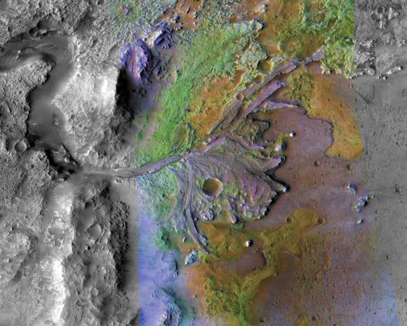
Jezero Crater on Mars was the landing site for NASA’s Mars 2020 rover. The colours in this image show surface minerals
detected by CRISM, which helped identify the crater as a desirable landing site. The green colour represents carbonates,
which are good at preserving fossils. Image Credit: NASA/JPL-Caltech/ASU
We already have the first portions of the new map. The final version of the map will contain about 51,000 540-kilometre-long strips, contained in 1764 tiles. In mid-June, NASA released 48 of those tiles, and they cover five of Mars’ most scientifically interesting regions.
The final map is a whole new data set and the first of its kind. The data has been gathered over the mission’s years but has never been put together, though mission scientists had this project in the back of their minds. “We’ve had the map tiles as a product set on the books really from the very beginning,” said Frank Seelos, a planetary scientist at APL and lead on the CRISM mapping project. “We knew we wanted to do this, but it took us many, many years to get to the point where we had enough data and the tools needed to make it worthwhile.”
More:
https://www.universetoday.com/156492/a-new-map-of-mars-made-from-51000-orbital-images/
