It's amazing what short range will do. We knew about Smokies miles from us.
Sure we did--u[ and down fairly straight and pretty level highways, or along valley floors and when we were lucky, along ridges and downhill from there. But AM is not terrain following like FM and doesn't do well in hill country.
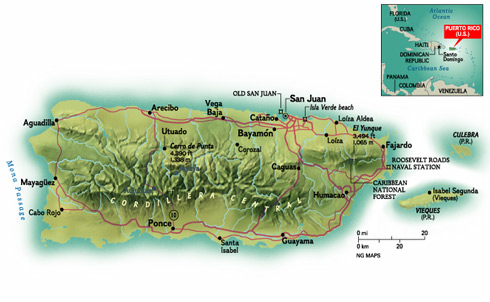
Topography
The territory is very mountainous (covering about 60%), except in the regional coasts, but Puerto Rico offers astonishing variety: rain forest, deserts, beaches, caves, oceans and rivers. Puerto Rico has three main physiographic regions: the mountainous interior, the coastal lowlands, and the karst area.
The mountainous interior is formed by a central mountain chain commonly known as the Cordillera Central, extending across the interior of the island, from Mayagüez to Aibonito, which transects the island from east to west. These mountain ranges are La Cordillera Central, La Sierra de Cayey, La Sierra de Luquillo, and La Sierra Bermeja.
The largest mountains are Cerro La Punta (1,338 m) in Jayuya; Rosas (1,267 m) found between Jayuya and Ciales, Guilarte (1,205 m) in Adjuntas, Tres Picachos (1,204 m) in Jayuya, and Maravilla (1,182m) in Ponce. Toward to the northeast is Sierra de Luquillo, whose highest peaks are: Toro Hill (1,074 m) found between Río Grande, Naguabo and Las Piedras, and El Yunque Peak (1,065 m) found in Río Grande. Another mountain chain is the Sierra de Luquillo in the northeast.
The second main physiographic feature is the coastal lowlands, which extend 13 to 19 km (8 to 12 mi) inward in the north and 3 to 13 km (2 to 8 mi) in the south. A series of smaller valleys lie perpendicular near the west and east coast. This area was originally formed by the erosion of the interior mountains.
The third important physiographic feature is the karst region in the north. This area consists of formations of rugged limestone dissolved by water throughout the geological ages. This limestone region is an extremely attractive zone of extensive mogotes or haystack hills, sinkholes, caves, limestone cliffs, and other karst features. The karst belt extends from Aguadilla, in the west, to a minor haystack hills formation in Loíza, just east of San Juan.
From
http://welcome.topuertorico.org/geogra.shtml Which contains much more info about the 100 mile X 35 mile island. But with mountains in the middle, the relay stations would have to go around, and reaching the interior might have similar difficulties to getting there by road. (trees down, etc., same basic troubles as anywhere else nailed by a Cat5 or Cat4 storm, and they got hit by two in rapid succession.
Then, there is the problem of having the fuel to keep the batteries charged to run the radios, and that is subject to a question of IF they are there at all.
I know I don't have one in a vehicle any more, and it is difficult to find the equipment locally (not like the old days).

