Beryl’s rainfall timeline for Houston, SE Texashttps://www.click2houston.com/weather/2024/07/07/beryls-rainfall-timeline-for-se-texas/
As of 1 PM, Beryl is still a tropical storm. As it inches closer to the Texas coast, it will strengthen to a category 1 hurricane by Sunday night. Beryl will then make landfall around 2 AM Monday near Matagorda, but its wind and rains will batter multiple communities as it continues to move inland throughout Monday.
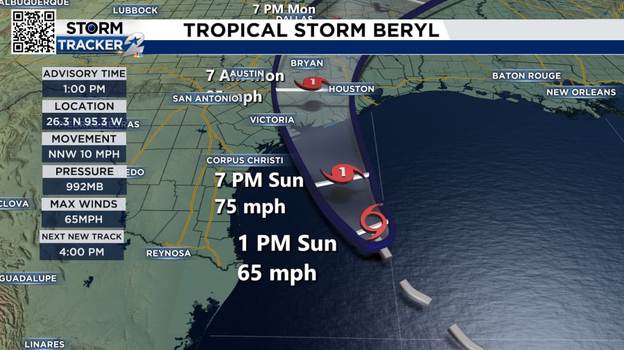
Tropical Storm Beryl is now 165 miles away from Matagorda; Landfall is expected overnight
Reviewing Beryl, it has a history of moving to the right and east of the forecast cone. The slight shift east means stronger tropical-storm-force winds for SE Texas. Galveston, Houston, Pearland, Pasadena, Katy, The Woodlands, and Liberty will see winds from 58 to 73 MPH. As for areas farther west like Needville, Sugar Land, Rosharon, Sargent, Matagorda, Port Lavaca, Wharton, and El Campo, winds will gust near 110 mph. This wind forecast means widespread power outages are likely, downed trees and potential damage to roofs.


