I see that there are lots of faults between the ongoing swarm on the NEV/CA border and Yellowstone. However, there does not appear to be ANY that run even close to that direction in a line. The fault lines are all more or less NORTH/SOUTH.
I understand your point. I'd love to see--whatever the statistic calculation is--getting rusty . . . the line that results from calculating a ?least squares? . . . . something . . . kind of averaging the scatter plot into a single ?trend? line.
That characteristic of a string of quakes between that part of CA up to Yellowstone has been more or less consistent for decades, IIRC. At least 20 years or more, that I've been noticing it.
It seems to me that, if your point was the deciding factor--only--the fault lines would have a variety of quakes scattered all over that region instead of more or less a line of them enduring over a long period of time from CA to Yellowstone.
I wonder where I could get a map of all the quakes in that region for the last 30 years.
Curious. Interesting. Any geologists to chime in?
I see there's a new quake the last hour at roughly the same spot as the earlier swarm on the southern 1/3 of the Salton Sea. Hmmmm And Brawley to the SE of there is still having a sometimes populated swarm, imho.
I am a geologist. I have chimed in. Any other geologists present are welcome to contribute as well, or even disagree with me or, in the event I have made a statement in error, to provide correction of that error.
The continent is not a homogenous mass, but is composed on sections which have been welded onto the continent during collisions with other continents or during periods of subduction. There have been a few of these periods, called orogenies. During these events, regional uplifting occurs, rock layers may be thrust onto younger rocks, faulting occurs-- low angle thrust faults during compressional episodes, tensional ("normal") faults during periods when the continents are separating, or the stresses are tensional. Faults can be more complex, but those are the basics. The valleys and mountain ranges of Nevada are a series of downfaulted valleys between uplifted blocks. You see something similar in Utah and Wyoming. The reason the faults trend the way they do is that they tend to parallel those old plate boundaries.
If you think of those layers of rock like pages of a book, it is possible to move them all in a row, but they are not on the same page, not in the same rock mass, and those stress points would not indicate a persistent rift cutting across all those lithic boundaries, but possibly the exertion of stress on different faults that persists throughout the Basin and Range.
At 17:30 in this video, the apparent string of earthquakes on entirely different fault lines is explained by tensional forces acting on the Great Basin
https://www.youtube.com/watch?v=1iTUAUmF-N4 These faults aren't connected, even though the same tensional forces are acting on all of them.
A shorter explanation of the formation of the continent is shown in this video:
https://www.youtube.com/watch?v=jzqnUvE66HA, which also explains the tension in the Great Basin (Basin and Range) Province.
Here is an article on the Geology of North America
https://en.wikipedia.org/wiki/Geology_of_North_America Which may help you envision how the different geological provinces are stacked onto the margins of the early continental crust.
Something that isn't mapped along with earthquakes, are the types of forces which cause the quakes: whether these are tensional forces, compressional forces, transform (slipping past each other) forces, or whether the earthquakes are directly related to activity in magma chambers.
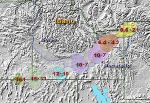
Note in this map...

(from
http://earthquake.usgs.gov/earthquakes/states/top_states_maps.phpThere is the apparent line you mentioned, but perhaps even more significant is the cluster of earthquakes trending roughly east/west along the track of the Yellowstone hotspot, as evidenced by past eruption scars
http://yellowstone.net/geology/volcano/ Note, too, that the fault trends were obliterated by passage over the hotspot and past eruptions.
 https://en.wikipedia.org/wiki/Yellowstone_hotspot
 shows a longer historical perspective,
While the linearity of the quakes you noticed may be related via the tensional stresses placed on the Basin and Range by drag along the San Andreas Fault (and associated faults), those are on different faults and do not indicate a fault trend in and of themselves, only places on the different faults where stresses have been relieved.